If you want to use Google Earth within your browser to measure distance, here is how. If you have a Google Earth-compatible browser installed, you can use this guide on Windows and Mac.

How to use Google Earth within Browser to measure Distance
To use Google Earth within a browser to measure distance, follow these steps:
- Open earth.google.com.
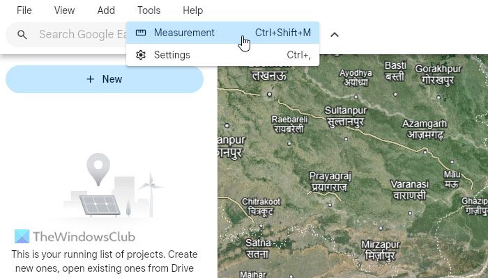
- Go to Tools > Measurement.
- Click on the starting point.
- Hover your mouse and click on the endpoint.
- Head to the Measure pop-up box.
To learn more about these steps, continue reading.
To get started, open the official website of Google Earth, earth.google.com, on your browser. You can use Google Chrome, Firefox, Microsoft Edge, etc. Then, go to Tools > Measurement.

Alternatively, you can press Ctrl+Shift+M. Then, you need to select the starting point from where you want to measure the distance. You can click on that spot on the visible map.
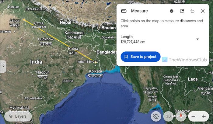
Then, hover your mouse to another location and click on it to mark it as the endpoint. Once you do that, it displays a yellow line along with a box named Measurement.

Here you can find the length or distance between those two locations. Expand the drop-down menu to select a desired unit e.g. Kilometer, Inch, Feet, Yard, etc.
However, if you want to measure the area of a location, you need to use the same option. Go to the same option called Measurement and choose a location as Point A. Then, use your mouse to select Point B, Point C, etc. The Measurement tool doesn’t stop unless you double-click on the endpoint.
On the other hand, you add more locations to an existing distance measurement line. For that, click on the white circle and drag it towards a different location that you want to add to the list.
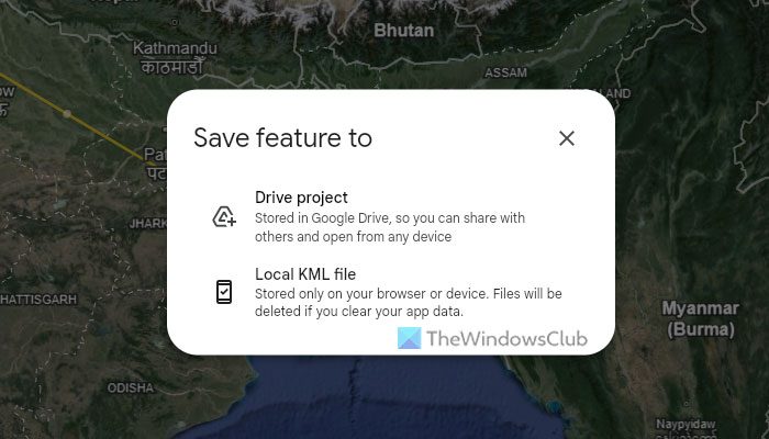
For your information, you can save the measurement data for future use. For that, click on the Save to project option.

Then, choose either the Drive project or the Local KML file option that fits your requirements. If you choose the former option, you can store the data in Google Drive and share it with anybody. However, if you choose the Local KML file option, you cannot do that. Apart from that, the data will be removed if you reset Google Chrome.
That’s all! I hope this guide helped you.
Read: How to find Addresses by Coordinates on Google Earth
How to measure distance on Google Earth on PC?
To measure distance on Google Earth on a PC, open the Google Earth application first. Then, go to Tools, select Ruler, and tick the Mouse Navigation checkbox. Then, use your mouse to mark two spots. It displays the distance between two spots on the Ruler pop-up window. For your information, you can change the unit from the drop-down menu.
How do I measure distance on Google Maps on browser?
To measure distance on Google Maps in the browser, right-click on a spot on the map. Then, choose the Measure distance option. Next, use your mouse to mark another point. Once you do that, the distance will be displayed on the screen along with a ruler or line.